The Villages of the Faroe Islands
Turf-roofed houses, waterfalls and dramatic cliffs make Faroese villages unforgettable stops on a North Atlantic journey.
Faroe Islands, North Atlantic · 8 min read · IGANAVI Editorial Team
Published August 11, 2026 · Updated November 16, 2026
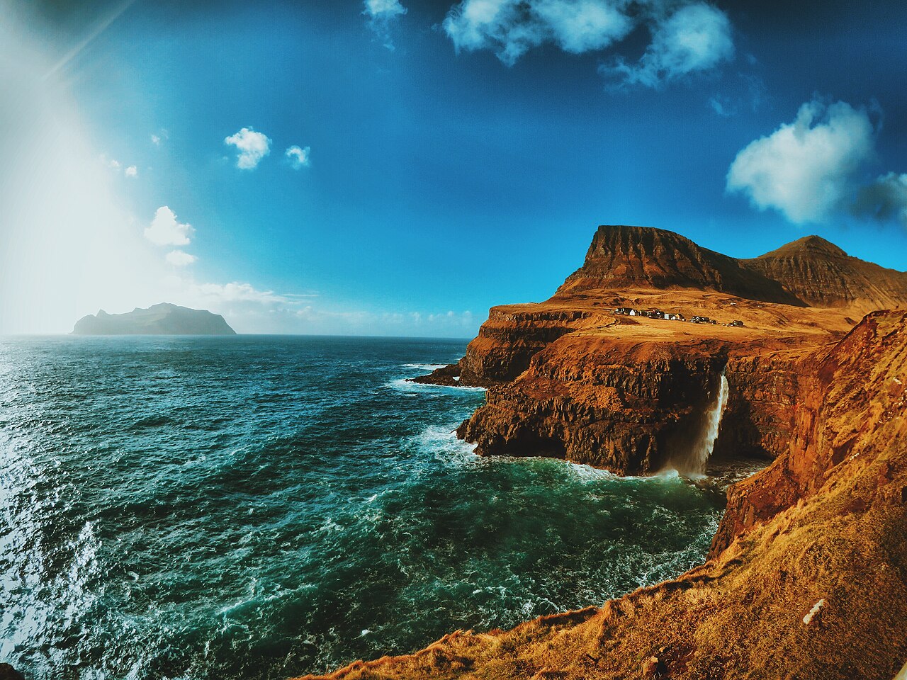
A Faroese village often reveals itself late. The road rounds a shoulder of mountain, the cloud lifts, and a few bright houses appear between rough pasture and the sea. There may be a harbour, a church and a bus shelter. Beyond them, sheep occupy slopes that look too steep to stand on.
These settlements are not an open-air museum. People mend boats, raise families and get on with work while visitors wait for the rain to stop. The most rewarding village journey leaves room for that ordinary life, rather than treating every turf roof as a photographic prop.
Finding your way through the islands
The Faroe Islands are a self-governing part of the Kingdom of Denmark in the North Atlantic, between Iceland and Norway. Eighteen main islands form the archipelago. Tunnels and bridges connect much of the central road network, but the map still needs careful reading: a nearby island is not necessarily a quick drive away.
Tórshavn, on Streymoy, makes a useful starting point. Walk through Tinganes, where small timber buildings and turf roofs share space with working government offices. The lanes are narrow and some doors lead directly into homes. Stay on public routes, keep voices low and resist stepping into a garden for a better angle.
You can organise several days around one base, or divide your stay between the capital and another island. Either way, avoid assigning every village a fixed hour. Low cloud may make a mountain road unappealing while a sheltered harbour elsewhere remains pleasant.
Roads, tunnels and public transport
Strandfaraskip Landsins, usually shortened to SSL, operates public bus and ferry services. Check its current timetables, service notices and reservation arrangements rather than assuming that a route runs frequently throughout the day. Some connections suit local commuting better than sightseeing.
The Eysturoy subsea tunnel links Streymoy with Eysturoy and includes its distinctive underwater roundabout. Other subsea tunnels connect parts of the archipelago, including Vágar and Sandoy with the central network. Toll arrangements differ, and rental companies may handle charges themselves. Ask how charges are collected before driving through.
Older single-lane tunnels require particular attention to signs, headlights and passing places. On narrow village roads, drive slowly and never stop in the carriageway for a photograph. A small distance on your phone can take longer than expected once weather, sheep and passing traffic are involved.
Gásadalur and the western edge of Vágar
Gásadalur sits beneath steep mountains near the western end of Vágar. Its road tunnel opened in 2004, changing access to a village previously reached over the mountain on foot, by boat when conditions allowed, or by air. Today the approach is straightforward in ordinary conditions, but the setting still feels exposed.
Múlafossur drops from the cliff beside the settlement into the Atlantic. Use the established viewpoint and respect barriers. Wind can lift spray above the cliff, and wet grass near an edge is not a safe alternative viewing platform. Sometimes cloud hides the upper slopes completely; the sound of water and the pale houses remain enough.
Walk through the village without rushing back to the car. Look at how buildings tuck into the land and how little shelter exists beyond them. Services are limited, and opening hours can be seasonal, so carry something to eat rather than counting on a particular café being open.
Nearby Bøur offers another village-scale stop, with views towards offshore islets when the weather clears. Choose a legal parking place and keep driveways free. Two unhurried stops on Vágar can be more satisfying than an afternoon spent repeatedly climbing in and out of a car.
Saksun and the changing lagoon
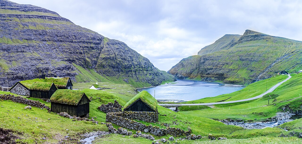
Saksun lies on Streymoy at the end of a valley, above a tidal lagoon enclosed by dark slopes. Turf-roofed farm buildings and the small church make an arresting scene, but this is working farmland as well as a visitor destination. Fences, gates and notices matter here.
The lagoon changes with the tide and weather. Do not infer that a stretch of exposed sand will remain accessible for your return. Check local advice before walking towards the sea, understand the tide, and turn back early if there is any doubt. There is no photograph worth being cut off by rising water.
Access conditions and charges can change, especially where walking routes cross private land. Read current signs and consult official visitor information before setting out. Paying for one route does not grant permission to wander through neighbouring fields or enter farm buildings.
Saksun rewards a quieter visit. Stand still long enough to notice water slipping through the channel and the shifting boundary between cloud and hillside. The weather has it's own timetable here, and the scene rarely stays the same for long.
Gjógv, where the harbour is a cleft in the rock
On northern Eysturoy, Gjógv takes its name from the sea-filled gorge beside the village. The narrow natural harbour gives the settlement a different shape from the broad bay villages: much of the drama is concentrated in that deep cut through the rock.
Watch the water from safe public viewpoints. In rough conditions, waves and spray can make the harbour surroundings dangerous. Steps and stone surfaces become slippery, and an apparently sheltered corner is not necessarily protected from a larger surge.
The road approach crosses high, exposed ground. Check conditions before committing to the drive, particularly outside summer. Once there, a short village walk may suit the day better than a longer hillside outing. Longer routes should be chosen using current local guidance, not simply because a line appears on a map.
Leave space between the famous stops
Eysturoy and Streymoy contain plenty of settlements that attract less attention than Gjógv or Saksun. A public harbour, a church exterior or a bench beside the water can provide a welcome pause. You do not need to discover a secret place to enjoy a quieter hour.
Keep these visits modest. Ask before photographing someone at work, do not obstruct fishing operations, and avoid flying a drone near homes, livestock or birds. Aviation rules and local restrictions need checking before any flight.
Kirkjubøur and the longer story
South of Tórshavn, Kirkjubøur brings the islands' medieval history into focus. The cathedral ruins, the old parish church and the historic timber farmhouse stand close together beside the sea. Their proximity makes this a useful place to slow down and think beyond the scenery.
The farmhouse remains connected to a living household, not simply a historic display. Enter only areas explicitly open to visitors and check current visiting arrangements. The same courtesy applies to the church, which may be in use rather than available for sightseeing.
From the shore, the view opens towards neighbouring islands. On a fine day it is tempting to extend every visit into a walk, but paths across the hills require suitable equipment and current access information. The village itself offers enough for a thoughtful stop without turning the afternoon into a hiking objective.
Seasons, food and the shape of a day
Summer brings long daylight hours and the broadest range of seasonal services. It is also the main period for seeing breeding seabirds, though individual species and colonies have their own timing. Rain, fog and strong wind remain possible. There is no reliably weatherproof month.
Autumn and winter offer shorter days, fewer visitor services and a greater chance of disruption. That can suit a trip centred on Tórshavn and accessible villages, provided you are comfortable abandoning plans. Exposed walks and remote ferry excursions need more caution than a simple seasonal packing list suggests.
Look for local fish, lamb and baking where available. Wind-dried foods reflect an older relationship with climate and storage, although flavours can be unfamiliar. Ask what a dish contains and mention dietary requirements early. In smaller settlements, bring water and a snack; there isn't always shops nearby.
Practical tips for a village journey
- Carry waterproof outer layers, warm clothing and footwear with a dependable grip, even for short stops.
- Check SSL service notices, road conditions and the local forecast each morning, then adjust your route.
- Confirm walking permissions, possible fees and guide requirements through current official tourism information and local land managers.
- Park only in designated or clearly permitted spaces, never on passing places or beside an obstructed gate.
- Close gates as instructed, give livestock room and keep away from nesting birds.
- Keep a spare day before an important flight if your plans depend on a weather-sensitive island connection.
A note on Mykines
Mykines is a separate undertaking, not a casual addition to a drive around Vágar. Seasonal boat access is weather dependent, and cancellation can affect both outward and return journeys. Check the current operator and official visitor guidance for sailing dates, reservations and disruption procedures.
Walking access is controlled, with guide and fee requirements applying to visitor routes outside the village. Routes can close for safety or wildlife protection. Do not assume the lighthouse path is open because an older photograph shows people there. Confirm exactly what your visit permits, and have a mainland alternative ready.
Frequently asked questions
Can I see the main villages without hiring a car?
Some are accessible using SSL buses, but frequencies and connections need planning. Check each outward and return journey separately. A guided excursion may help with harder-to-combine stops, while Tórshavn itself is easy to explore on foot.
Is every village walk free to enter?
No single rule covers every place. Public streets differ from hiking routes over private land, and some routes have charges or guided-access conditions. Read notices and check current official guidance rather than assuming open countryside means unrestricted access.
How many villages should I plan in one day?
Two or three nearby settlements usually leave more room for weather and wandering than a long checklist. Add less, not more, when a ferry or exposed road is involved. The best memory may be the hour you had not scheduled.
Related guides

Santorini, Greece
Santorini's Villages Beyond Oia
Hilltop Pyrgos, cliffside Imerovigli and the wine villages of the south reveal a quieter side of Santorini.
Island Villages · 9 min read
Venetian Lagoon, Italy
Burano: The Island of Colour in the Venetian Lagoon
Bright houses, quiet canals and a lace-making heritage make Burano one of the lagoon's most charming villages.
Island Villages · 8 min read
Seychelles, Indian Ocean
Seychelles: Granite Boulders and Endless Light
Ancient granite, quiet coves and forested peaks make the Seychelles feel unlike any other tropical archipelago.
Tropical Islands · 9 min read